South African meteorologists on Tuesday issued a Level 8 severe weather warning, their highest non-cyclone alert, forecasting record wind speeds and heavy rainfall across multiple provinces over the coming days. The warning covers Gauteng, KwaZulu-Natal, the Eastern Cape, and surrounding regions, with conditions expected to peak between Wednesday evening and Friday morning.
Unprecedented Weather System Takes Aim at South Africa
The South African Weather Service confirmed the warning after satellite imagery revealed a storm system gathering strength over the Indian Ocean. Meteorologists said wind gusts could exceed 120 kilometres per hour in some areas, surpassing anything the region has experienced since 2019. The storm is classified as a cut-off low pressure system, a phenomenon that forms when atmospheric circulation traps cold air in a rotating pattern.
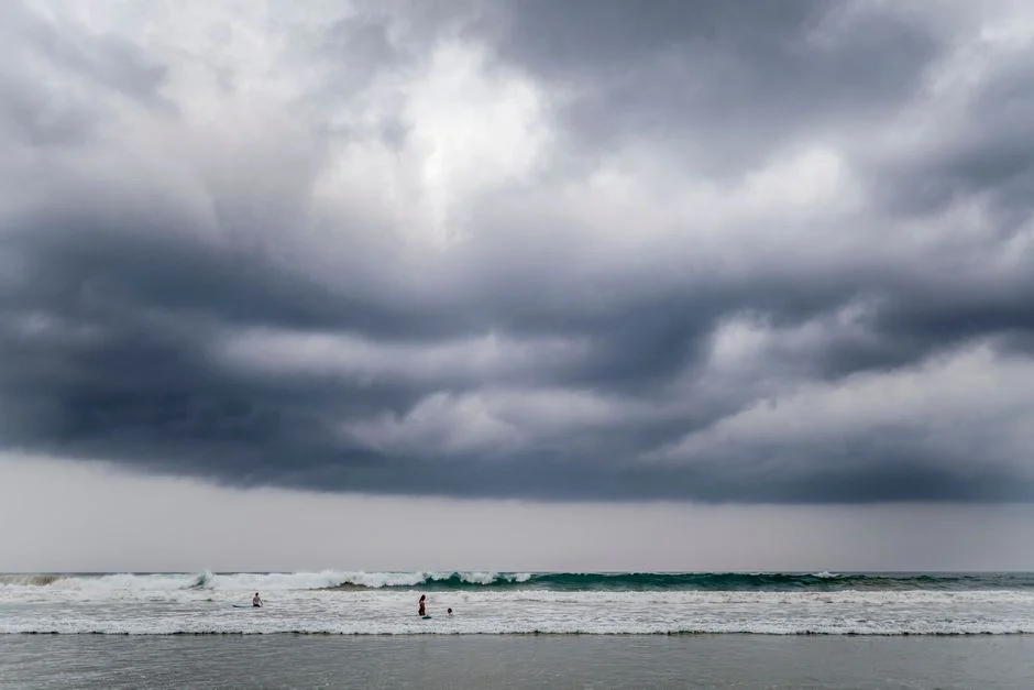
Here is why that matters: cut-off low systems are notoriously difficult to predict because they move slowly and can dump extreme amounts of rain in concentrated areas. The South African Weather Service stated that rainfall totals could reach 200 millimetres in high-lying regions, enough to trigger flash flooding and landslides.
Government Agencies Activate Emergency Protocols
The National Disaster Management Centre in Pretoria activated its emergency coordination centre on Tuesday afternoon, linking provincial disaster offices with municipal responders. The South African National Defence Force confirmed it has placed disaster response units on standby. Schools in low-lying areas of KwaZulu-Natal have begun precautionary closures, with the provincial education department urging parents to collect children early.
The South African Weather Service is distributing alerts in all eleven official languages to ensure rural communities receive adequate warning time. Municipal water and sanitation departments are clearing storm drains and securing temporary barriers near flood-prone informal settlements.
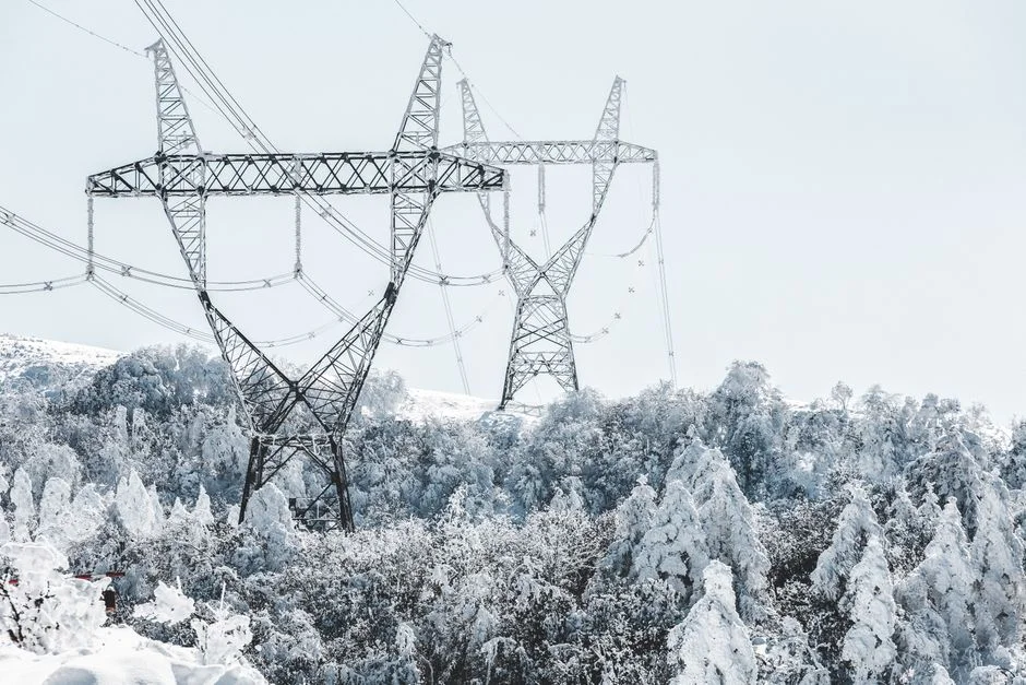
Power Infrastructure Braces for Impact
Eskom, the state electricity utility, has pre-positioned repair crews across Gauteng and KwaZulu-Natal. The power grid faces particular strain because the same storm system will coincide with high electricity demand during cold winter conditions. The utility warned that load shedding cannot be ruled out if transmission infrastructure sustains damage.
Telecommunications companies are running generator tests at base stations to maintain network coverage during potential power outages. Cell C, Vodacom, and MTN each confirmed contingency plans to handle emergency call volumes during the storm.
What the Level 8 Classification Means for Communities
South Africa's severe weather warning system runs from Level 1 to Level 10, with Level 8 reserved for events that pose a serious threat to life and property. Below Level 8, conditions are dangerous. At Level 8, they are life-threatening. The South African Weather Service uses this classification to trigger mandatory emergency protocols across government departments.
Disaster risk management practitioners note that Level 8 warnings give municipalities legal authority to evacuate areas without resident consent if conditions deteriorate. The South African Weather Service is expected to provide updates every six hours as the system approaches.
Economic and Infrastructure Risks Across Affected Regions
The Port of Durban, one of Africa's busiest maritime hubs, has begun securing cargo and suspending operations ahead of the storm. Shipping traffic through the port will likely face delays of 24 to 48 hours. The South African Airways maintenance facility at OR Tambo International Airport is protecting aircraft and ground equipment.
Miners in the Northern Cape and Free State have suspended open-pit operations where wind speeds could destabilise equipment. The Minerals Council South Africa confirmed mining companies are following safety protocols that require personnel evacuation when wind thresholds are breached.
The storm's trajectory passes directly over several coal-fired power stations in Mpumalanga, raising concerns about ash containment systems at retired facilities. The Department of Environment, Forestry and Fisheries has been notified but has not issued additional directives.
Preparedness Gaps and Vulnerable Communities
Emergency management authorities acknowledge that informal settlements in Ekurhuleni and eThekwini remain the most vulnerable to storm damage. Structures built from corrugated metal and wood offer little protection against wind speeds exceeding 100 kilometres per hour. Non-profit organisations operating in these areas have begun distributing emergency tarpaulins and sandbags.
The South African Red Cross confirmed it has pre-positioned relief supplies including blankets, water purification tablets, and first aid kits in three strategic locations. The humanitarian organisation told reporters it is coordinating with municipal emergency services to ensure aid reaches affected communities within 24 hours of the storm making landfall.
Continental Context and Why This Warning Matters Beyond South Africa
While the storm will strike South Africa directly, its formation follows a pattern that climate scientists have linked to shifting Indian Ocean temperatures. Research published by the African Climate and Development Institute suggests that warming ocean surfaces are increasing the frequency of intense cut-off low systems along southern Africa's coast. This has implications for infrastructure planning across the region.
The storm comes as several African nations are investing heavily in climate resilience programmes under the African Union's Agenda 2063 framework. South Africa's ability to coordinate a national emergency response offers a case study for other countries developing early warning systems. The Southern African Development Community's disaster risk reduction unit is monitoring the situation and stands ready to coordinate cross-border assistance if needed.
African meteorological agencies, including the Kenya Meteorological Department and the Mozambique National Institute of Meteorology, are tracking the system for potential secondary effects on their territories. Climate models suggest that storm tracks are shifting southward, reducing direct risk to East Africa but increasing exposure for Southern African coastal communities.
What Comes Next as the Storm Approaches
The South African Weather Service will release its next comprehensive update at 18:00 local time on Wednesday. Emergency management officials are urging residents in affected provinces to secure loose outdoor items, charge electronic devices, and identify their nearest community shelter.
Provincial disaster management centres across Gauteng, KwaZulu-Natal, and the Eastern Cape have opened information hotlines. The public is advised to monitor official channels rather than relying on social media reports, which officials say have historically spread misinformation during severe weather events. Additional evacuation orders may be issued as the storm moves closer and forecasters gain confidence in predicted impact zones.
See Also
- Headway Broker Enters Nigeria: Forex Market Set for Major Shift
- Festival da Canção: A Cultural Catalyst for Development in Nigeria
The Minerals Council South Africa confirmed mining companies are following safety protocols that require personnel evacuation when wind thresholds are breached.The storm's trajectory passes directly over several coal-fired power stations in Mpumalanga, raising concerns about ash containment systems at retired facilities. The Department of Environment, Forestry and Fisheries has been notified but has not issued additional directives.Preparedness Gaps and Vulnerable CommunitiesEmergency management authorities acknowledge that informal settlements in Ekurhuleni and eThekwini remain the most vulnerable to storm damage.
What is the latest news about south africa issues level 8 storm warning record winds expected?
Why does this matter for environment-nature?
What are the key facts about south africa issues level 8 storm warning record winds expected?